What We Currently Know About Low-Level Wind Shear
What is it, why it matters, how was it formed, and how to detect it (or if it possible, predict it)
What is Low-Level Wind Shear?
Low-level Wind Shear (LLWS) is any sudden significant change of wind (wind direction or wind speed or both) in a horizontal or vertical way that happens in the near ground altitude. How tall is “near ground altitude”? Some literature says it’s < 600 meters above the ground, < 500 meters, and < 300 meters. LLWS duration is very short, that is, only a few minutes.
Why It Matters?
It matters especially in the aviation sector. Take-off and landing is a crucial time for aircraft. The pilot must condition the aircraft to follow the wind conditions on the runway. So, any significant change of wind that doesn’t count can make the conditioning make by the pilot is in vain, and accidents may happen. According to the National Transportation Safety Board, wind shear causing dozens of aircraft accidents with a total of over 500 fatalities.
How Was It Formed?
LLWS occur due to several causes, such as:
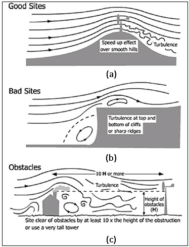
- Local topography, such as mountains, buildings, trees, etc any obstacle in the land. When the wind blows from the direction of the obstacles, it will be turbulent when it reaches the runway and LLS happens. This kind of LLWS happens either when the weather is clear or not, it’s unpredictable. That’s why the runway area must be cleared from any obstacle.

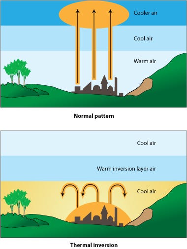
- Thermodynamic inversion, this happens when the warmer air layer is above the cooler air layer. The winds in the cool air layer usually calm on the contrary with the winds in the warm air relatively strong. Thermodynamic inversion commonly happens at night or early morning. The LLWS happens in the boundary layer between warm air and cold air.


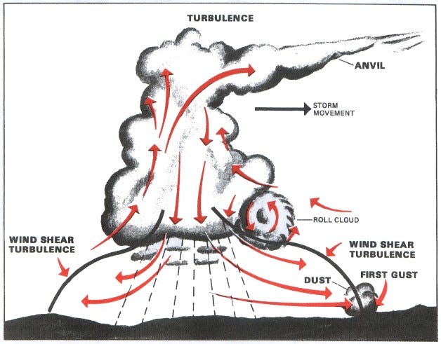
- Convective cloud is the most reason for bad weather. Besides from being the cause of thunderstorms and heavy rain (and hail), it can cause LLWS. The source of LLWS in the convective cloud is the first gust and downburst. As the name suggests, the first gust is the first gusty wind that hits the ground before the real storm coming. The Downburst is the gusty wind that hits the ground when the cloud in the decay phase. Both of these wind is come from above (from the convective cloud) towards the ground and when it hits the ground, it’s spread in all directions (divergence).

- Warm/cold front can cause LLWS only if:
- The temperature difference at the boundary layer is more than 5 Celcius degree.
- The front moving at least at 30 knots.
How to detect it (and predict it if possible)?
Many instruments can detect this phenomenon. It is hoped that when this phenomenon is detected, pilots can be warned that LLWS is happening at that time. These instruments come with pros and cons. They are Doppler Radio and Detection Ranging (Radar), Terminal Doppler Weather Radar (TDWR), Doppler Light and Detection Ranging (Lidar), Automatic Weather Observing System (AWOS) and Low-Level Wind Shear Alert System (LLWAS). Doppler Radar, Doppler Lidar, and TDWR is a remote sensing instrument. They are emitting Electromagnetic signals to the atmosphere and reflected back by particles in the atmosphere. The reflected signal is processed so the wind speed and direction in the atmosphere in 3 dimensions can be known. LLWAS and AWOS are based on an anemometer sensor. They can’t detect LLWS in 3d sense.
Here are the pros and cons of the instruments to detect LLWS.
Doppler Radar
Pros:
- has a broad coverage area.
- can detect horizontal and vertical LLWS.
Cons:
- Not effective when the weather is clear.
- Its spatial resolution is inferior to Doppler Lidar and TDWR.
TDWR
Pros:
- Has a high spatial resolution.
Cons:
- Not effective when the weather is clear.
Doppler Lidar
Pros:
- Has a high spatial resolution.
- Work well in clear weather.
- can detect horizontal and vertical LLWS.
Cons:
- The coverage area is limited (more limited than TDWR).
LLWAS
Pros:
- Work wether when the weather is clear or not.
- Has an excellent time resolution (usually 10 seconds).
Cons:
- The coverage area is limited (only in the area surrounded by the sensors). The Newest LLWAS algorithm can detect the possibility of LLWS in the outside of the sensors network.
- Can only detect horizontal wind shear. This is can be fixed with installing sensors with different height.
Especially for AWOS, on the first hand, it’s not designed to detect LLWS. AWOS can detect gust wind speed as is an anemometer works (AWOS has multiple sensors to measure weather parameters) only at the point where it is installed. So, its coverage area is very limited. Some studies using Support Vector Machine (SVM) and Compressive Sensing (CS) to fastening the detecting of LLWS by remote sensing instruments. The study that uses SVM do an automatic classification and only uses a portion of the remote sensing image (1/3 of the whole image) to shorten the processing time but the accuracy obtained is not accurate (at all schemes, the highest accuracy is only 50%) so it is less reliable. For the study that using CS, they fastening the detection by doing a sparse sampling (does not take and whole pixels so that the image capture process is fast) and reconstruct it using CS. The reconstructed image generated by CS is quite close to the original image and the classification of LLWS is doing by humans.
Recent studies using Numerical Weather Prediction (NWP) to predict LLWS. The spatial resolution of the model used is very subtle, which is several hundred meters with timestep from a few minutes to an hour. From the model output, head/tail wind is calculated using a simple vector calculation so that an early warning can be issued. To verify the result of the model, recent studies using all instruments that can detect LLWS (Doppler Radar, TDWR, Lidar, LLWAS, AWOS). Some studies that have an hour timestep using stability index like turbulence Index 1 (TI1), Turbulence Index 2 (TI2), and Richardson Number (Ri), etc to detect LLWS potential.
References
Didane, Djamal & Wahab, A. & Shamsudin, Syariful & Rosly, Nurhayati. (2016). Wind as a sustainable alternative energy source in Malaysia — a review. 11. 6442–6449.
Hallowell, R. G., & Cho, J. Y. (2010). Wind-shear system cost-benefit analysis. Lincoln Laboratory Journal, 18(2).
Hon, K. K. (2020). Predicting Low-Level Wind Shear Using 200-m-Resolution NWP at the Hong Kong International Airport. Journal of Applied Meteorology and Climatology, 59(2), 193–206.
Ma, Y., Li, S., & Lu, W. (2018). Recognition of partial scanning low-level wind shear based on support vector machine. Advances in Mechanical Engineering, 10(1), 1687814017754151.
Ma, Y., Li, S., & Lu, W. (2019, January). Quickly Sample and Reconstruct for Low-level Wind Shear Data Measured by Coherent Lidar. In 2019 IEEE 2nd International Conference on Electronic Information and Communication Technology (ICEICT) (pp. 278–282). IEEE.
Nangimah, E. W., 2017, Simulasi Low Level Wind Shear Menggunakan Model
WRF-ARW dan Radar Cuaca EEC di Bandara Internasional Soekarno-
Hatta (Studi Kasus tanggal 2, 11, dan 19 Desember 2016), Skripsi, Program
Sarjana Terapan Meteorologi, STMKG, Tangerang Selatan.
Ratnasari, Y., 2018, Validasi Efektivitas Alert Wind Shear pada LLWAS di Bandara Internasional Soekarno-Hatta Menggunakan Data Pilot Report, Radar Doppler, dan Automated Weather Observing System (AWOS), Skripsi, Program Sarjana Terapan Meteorologi, STMKG, Tangerang Selatan.
Zhang, H., Wu, S., Wang, Q., Liu, B., Yin, B., & Zhai, X. (2019). Airport low-level wind shear lidar observation at Beijing Capital International Airport. Infrared Physics & Technology, 96, 113–122.
https://www.sciencelearn.org.nz/images/1883-temperature-inversion accessed on 19 July 2020
https://www.aviationweather.ws/046_Wind_Shear.php accessed on 19 July 2020
https://www.aviationweather.ws/063_Hazards.php accessed on 19 July 2020
https://www.aviationweather.ws/041_Fronts.php accessed on 19 July 2020
